Race Report:- Kong Mini Mountain Marathon Series: Peak District (25/11/2018)
Date: 25/11/2018 (Sunday)
Distance travel: 15.9km
Elevation: +405m/-422m
Time: 04:05:50
After a month
swapping the fells with the soft trail behind my house, I started to feel the
itch to be outside in the fells but my right leg is still recovering from the
tumble I took during the Lakes in the Day event last month. This is where Kong
Mini Mountain Marathon come in.
I
did a navigation course organized by the Fell Runner Association in September.
(Un)fortunately the navigation happened during a sunny spell in the Lakes
District, so apart from the night navigation exercise, everyone can see where
the control points are and the folks in front of them. Today’s event really put
my navigation skills to the test.
My
objectives for this event are; i) work on my navigational skills, ii) enjoy the
hills/fells regardless its conditions and iii) getting some elevation in as I
have been stuck in flat Norwich for a month now.
Mountainmarathon is where the fell running and orienteering intersects. Participation
happened in a team of 2 where items like tent, sleeping bag and food are
carried for 2 days. In the morning of the first day, participants will get a
map with numerous control points and the location of the camp site for that
night. How fast and hard a team wants to complete the course depend on the
category they have opted for during the registration.
How a mountain marathon in Alps looks like.
KongMini Mountain Marathon series provided the mountain marathon experience in the
space of 4 hours in the fells. The series consists of 4 events in the fells of
Lakes/Peaks/Wales. The principles of mountain marathon still apply only there
is no requirement for it to be done in team of two and of course, no need to
carry a tent.
The
registration happened at the Hathersage Village Hall. I arrived around 7.50 am
with the intention of starting before 8.30 am. After getting my dibber, going
through kit check and messing around, I walk to the start of the course. The
start is located 10 min away from the village hall. I got the map and my clock
started at 8:25am. Foolishly I did not strategize my travel and just walk the
path in front of me. I’m not sure legs are hill-fit so I just hike up. I got to
my first intended control point after 42 minutes with a help from another racer.
Hidden away
Then
it was a series of jog to other control points. The time lag between control points
get shorter once I got the hang of this event. I checked my bearings and map way too
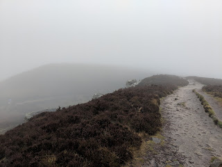
many times to ensure I am in the correct line and not drop from a cliff! In one
section, I did traverse in a huge bog patch cause my compass told me to go
there!
Not sure how to explain this route choice.
I
only have a strategy after my 4th control. I estimated with the time
I have it is possible to go to 3 more controls. However, I spend too much time on
the search for the 5th control. Part of it involved looking for a
section of a river that I can safely cross and treading carefully in patches of
mud. My right leg went into a muddy bog up to my knee one time. Then I got to
the junction that enabled me to get to the 6th control. A quick
glance to my watch and I realised that I have less than 35 min to get to the
base before I bleed points. I get as fast as possible to the nearest road and
run to the base (i.e. the only time today I’m running).
Once
I got back to the village hall, I change into another set of clothes. A lady
allowed me to use her body spray helping me to pong less on the train ride to
Norwich. After that its time for tea and cakes!
Cakes!!!
I
finished 208th out of 221st runners/teams in this event. I’m
using this event to dip my toes into the world of mountain marathon. So, I’m fine with the results as I enter this event not to be competitive. The person that finished first collected 700/770 points! Must be a super fast runner and experienced mountain marathon guy.
I
do hope the stars will be aligned in February 2019 so I can do another event in
this series in Wales.
Lessons
from this event:
- Get the scale right from the start! I thought I was working with 1:40000 map when in fact I am working with 1:3000 map.
- A mark circle that have control point covers an area of 20-30 meters. When the clue said it is under a big rock, don’t search around a sofa-sized rock. Search it under a rock that is a huge as a car!
- I should form a strategy the instant I got the map, and not chase the closest control points to me.


Comments
Post a Comment